
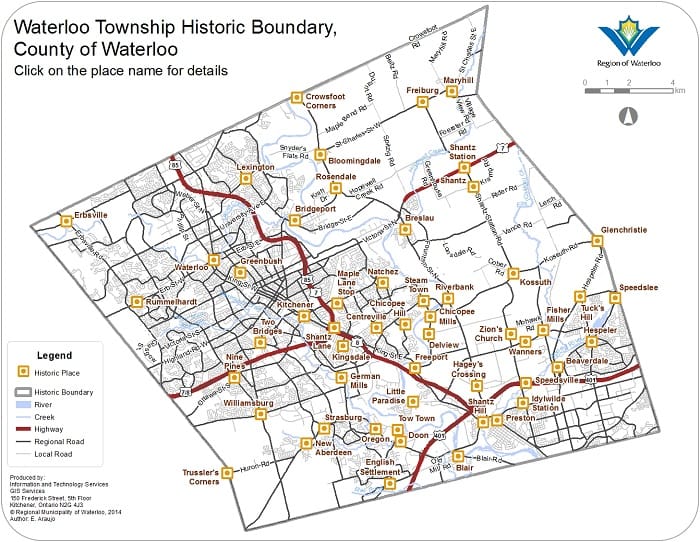
Waterloo Township was originally an area of land known as Block Two of the Grand River land grant donated by the British to the Six Nations First Peoples during the late eighteenth century for their loyalty to the Crown in the American Revolutionary wars. When Block Two was incorporated in the District of Gore in 1816, it became Waterloo Township, named in honour of the battle that ended the Napoleonic Wars in Europe. The township was the first of Waterloo County's five townships to be settled. In many regards, its settlement laid the foundation for the later settlement of other townships in Waterloo County, with a pool of pioneering experience and a source of supplies. The first immigrants to settle in Waterloo Township were almost exclusively German Mennonites from Pennsylvania. Most of these settlers were farmers but many were tradesmen and millers. The Mennonite presence left an indelible mark upon the history of Waterloo Township, inspiring many of its place names, shaping the political atmosphere, and the landscape. Later settlers were generally of Scottish, English, Irish, and continental German heritage, many of them farmers, but a majority of them tradesmen, businessmen, and professionals. They attracted and aided the majority of industrial development in Waterloo Township. When the railway was laid through Waterloo Township in the mid-nineteenth century, it became the leading industrial centre of Waterloo County.
Waterloo Township (Block Two), a 94,012 acre tract, was first acquired by Richard Beasley from Joseph Brant on behalf of the Six Nations in 1796.[1] Until the Six Nations received full mortgage payment for this sale, Beasley was prohibited by deed from subdividing the land or selling plots within it.[2] However, in order to fulfill his mortgage payments to which he had agreed, Beasley sold portions of Block Two land anyway. In 1800 alone, for example, Beasley sold over 14,000 acres to a number of Mennonite settlers from Pennsylvania. They were unaware that Beasley had not yet fulfilled his mortgage obligations, and that they would not receive legal title to their land until he did.[3] When Beasley's actions were revealed a short time later, panic rose among the Mennonite buyers who feared they would lose everything they had paid. To correct the situation, a formal agreement was arranged between Brant and Beasley. This arrangement allowed Beasley to sell the bulk of Block Two in order to cover his mortgage obligations completely, while giving the Mennonite buyers legal title to land they had previously purchased. Subsequently, Beasley sold a 60,000 acre tract of land to the German Company of Pennsylvania represented by Daniel Erb and Samuel Bricker in November 1803. Beasley's sale to the German Company not only cleared him of a mortgage debt, but left him with 10,000 acres of Block Two land which he continued to sell into the 1830s.[4]
The German Company was composed of a group of Mennonite shareholders mainly from Lancaster County Pennsylvania. They wished not only to settle in Block Two but to aid their fellow friends, both within the Company and without, who had previously purchased Block Two land from Beasley.[5] The last payment of their purchase from Beasley was made in 1804. This large payment of cash was transported from Pennsylvania by Company members Samuel and John Bricker; and Daniel, Jacob, and John Erb. As tradition has it, this journey was an eventful one.[6] The payment money was secured in an oak keg attached to a wagon that was led by one of the Company men. The remaining men, armed with muzzle-loaders, mounted on horseback to guard the wagon as it made its journey north. However, while the men were resting one evening, several bandits dashed in on them suddenly with the intention of stealing the money. Prepared for such an invasion, the Company men scattered the bandits off in all directions. Apparently, the bandits had been following the Company men suspiciously for several days, and subsequently, the Company men were ready for such a surprise attack. Consequently, the full payment price for German Company land was safely delivered intact to Beasley in Waterloo Township.
The 60,000 acres of Block Two land that the German Company acquired was surveyed into 128 lots of 448 acres each and 32 lots of 83 acres each. Each shareholder's lot was randomly selected so that all would be given an equal and fair chance to win the best lots. For this reason, shareholders with more than one share received lots that were not necessarily adjacent to one another. Moreover, because the German Company land had no formal survey with road concessions plotted out, roads that were later built in the township were often inconsistent with others in the area.[7] Depending on the location of natural boundaries like the Grand River, lots were also laid out rather awkwardly which often contributed to somewhat haphazard patterns of road development.
Prior to 1830, the majority of settlers in Waterloo Township, including those of the German Company, were Mennonites--mainly from Lancaster and Montgomery Counties in Pennsylvania.[8] Although a smaller number of other immigrant groups settled in the area at this time including Pennsylvanian River Brethren (also known as Dunkers or Tunkers), the Mennonite population was dominant in the early years. For example, of the 1,640 people residing in the township in 1825, 1,000 were Mennonite.[9] However, a significant area of Block Two, almost one third or roughly 30,000 acres, was not sold to the German Company. This area was called the Lower Block (of Block Two). Although much of the heartland of the Lower Block along the Grand River was sold to settlers from Pennsylvania, significant pockets of property throughout the Lower Block were also sold to settlers from the British Isles and from Germany, resulting in a diversity of cultures in areas such as Freeport, the English Settlement and Hespeler.

Raising of the Hallman Barn, Waterloo Township, ca. 1905.
DHC 974.081.001
Several factors had encouraged Mennonite immigration to Waterloo Township. By the end of the eighteenth century, land had become increasingly scarce in Pennsylvania. The prospect of utilizing land for farming in an area where land was plentiful was especially appealing to those Mennonite groups who wished to continue their traditional way of life as farmers.[10] Secondly, a severe agricultural depression in Lancaster County during the 1820s forced many to look abroad to the virgin lands of Canada where an agricultural future looked more promising.[11] Finally, because Mennonites feared that their pacifist beliefs might be put into question if another American revolutionary war was to occur, the British-controlled lands of Waterloo Township seemed a safe haven.[12]
Although a small number of Mennonite and other settlers operated saw mills and other such enterprises, the majority were farmers in the formative years. Although the township was large in size, most settlement fell along the Grand River running through the middle of the Township. Although this area of the township was not the most agriculturally fertile, until about 1820, it was the most geographically accessible. After this time, the development of road and trail structures encouraged development in other areas of the township.[13] Between 1800 and 1820, nearly a hundred families settled in the area.[14] In 1818, the township had reached a population of 850, and by 1831, it had risen to 2,002.[15]
By the early 1830s, essentially all of Block Two land had been sold; over the next several decades, properties were subdivided and resold. By the second half of the nineteenth century, the majority of land in the township had by this time been re-sold; new settlers in the township were generally not land owners or farmers. They came to work primarily as artisans, labourers, shopkeepers, and millers in developing communities of the area. Groups or individuals interested in buying land moved into townships elsewhere in the County, including Wilmot and Woolwich, where the land was still ripe for development.
Although the origins of the first settler groups in the township were predominantly Pennsylvanian Mennonites, from the early 1830s the origins of settler groups diversified to a much greater degree. Many settler groups emigrated from England, Ireland, Scotland and Germany to areas such as New Germany in the north-east portion of the township, and the Lower Block of Block Two. Religious affiliations of these groups were predominantly Catholic, Lutheran, Presbyterian, and Methodist; a small number of new Mennonite settlers came into the township as well. Because of an increase in the cultural variation in Waterloo Township after 1830, proportionately the Mennonite population began to decline. For example, in 1835, approximately seventy percent of the population was Mennonite.[16] By 1851, only twenty-six percent of the population was Mennonite. However, while the Mennonite population declined, the township's population increased substantially. In 1835 the township's population was 2,791; in 1841, Waterloo Township had the greatest population of any of the townships in the County.[17] By 1851, its population had grown to 8,878.[18]

Farm of Cornelius and Abraham Panabaker near Hespeler,
Waterloo Township, 1894. DHC X.964.536.001
New settlers in Waterloo Township formed thriving urban communities which served the needs of the nearby farming communities. By damming creeks and brooks they put into operation a number and variety of water-powered mills including saw mills, flour mills, and grist mills. By 1848, for instance, there were eleven grist mills in operation in the township.[19] Many mill sites possessed more than one mill operation and sometimes possessed a distillery as well. In the village of Doon, for example, a large milling enterprise was in operation by 1839, including a saw mill, a distillery, and a grist mill. This enterprise was the largest in Waterloo Township at the time. Other industrial businesses of the township included tanneries, of which there were eight in the township by 1851,[20] and factories that manufactured such implements as agricultural equipment and furniture. Such small scale industries not only attracted settlers with trade skills and know-how, but attracted settlers also wishing to establish small scale businesses of a secondary nature including storekeepers, butchers, and coopers. The development of small industries consequently promoted both the settlement of small villages and hamlets, as well as lines of communication like roads and bridges.
In the mid-1850s, the defining development of Waterloo Township and Waterloo County was the construction of the railway. Worldwide, railways revolutionized the progression of modern society; Waterloo Township was no exception. The first railway line built in Waterloo Township was a main line of the Grand Trunk Railway from Toronto. It was laid through the township in 1856, making three main stops: Shantz Station, Breslau, and Berlin. Not only did the railway boom provide employment for settlers already in the area, but it also encouraged further settlement. Berlin, which had become the county seat of government in 1853, would soon become the leading industrial centre of the township as well as the county. A number of small communities would slowly be absorbed by Berlin as it expanded.
A number of other railway lines were soon laid across the township including: a Grand Trunk branch between Preston and Berlin in 1857; a Great Western line from Galt, Preston, and Guelph in 1857; a Grand Trunk branch between Waterloo, Berlin, and Galt in 1882; and a Grand Trunk Branch between Waterloo and Elmira in 1891. These railway lines also encouraged settlement and industrial development in Waterloo Township, especially in Preston and New Hope (Hespeler). Some communities, including the village of Doon, were formally laid out for development in anticipation of the railway boom; however, the hopes of some real estate dealers failed to materialize because of the strong head start enjoyed by Berlin from the 1850s. By the turn of the twentieth century, economic life in Waterloo Township turned around the central towns of Waterloo and Berlin. A similar pattern of development continued well into the twentieth century.
With the formation of Regional Government in 1973, the still-growing cities of Waterloo and Kitchener absorbed the former western section of Waterloo Township, while the part of the township lying east of the Grand River was absorbed into an enlarged Woolwich Township. The historic heart of the County, the formative township, ceased to exist as a political entity, although the character of its founding peoples continues to influence cultural life to the present day.[21]
[2] Ezra E. Eby, A Biographical History of Waterloo Township: and Other Townships of the County: Early Settlers and Their Descendants, 14-5.
[3] I.C. Bricker, "The History of Waterloo Township Up To 1825," Waterloo Historical Association, (1934), 83-5.
[4] Elizabeth Bloomfield, Waterloo Township through Two Centuries (St. Jacobs: 1995), 23.
[16] John English & Kenneth McLaughlin, Kitchener: An Illustrated History (Waterloo: 1983), 26. See also Geoffrey Hayes, 14.
[21] Elizabeth Hardin Macnaughton, Peace and Prosperity; Waterloo County - Waterloo Region, 1853-1993 (Kitchener: Regional Municipality of Waterloo, 1993), 11.


